Record‑Early Polar Vortex Collapse Signals Possible Cold Snap in Winter
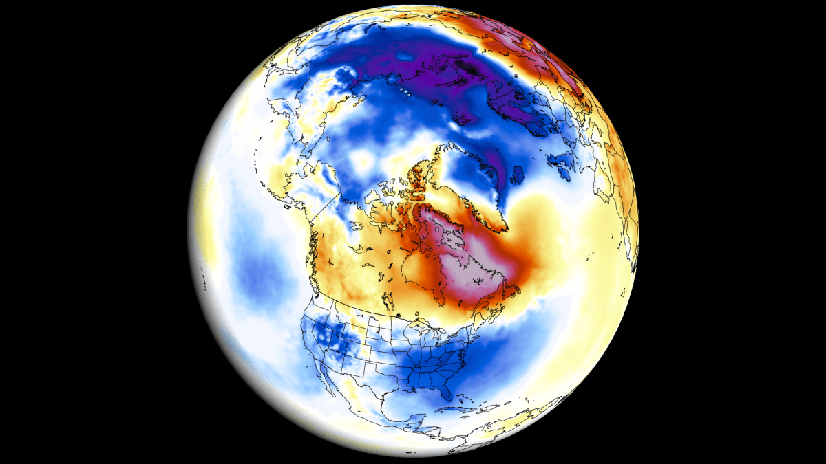
Stratospheric winds are slowing to near zero and are set to reverse, marking the earliest Sudden Stratospheric Warming on record.
Early Breakdown of the Polar Vortex
The Polar Vortex is currently losing strength weeks ahead of the usual schedule. Stratospheric winds have dropped to near zero and are forecast to reverse in the coming days, creating the earliest Sudden Stratospheric Warming (SSW) event on record.
What the Disruption Looks Like
3‑D visualizations show a highly disturbed vortex, with the core splitting into two separate areas at the 10 mb level (about 30 km altitude). Temperatures in the stratosphere are projected to rise more than +27 °C (49 °F) above normal for this time of year.
Monitoring the vortex relies on stratospheric wind direction: strong westerly flow signals stability, while weak or easterly flow indicates a reversal and breakdown. The latest analysis shows winds well below normal, even lower than the previous record low for this season, and a projected reversal on Friday when winds first reach zero.
Forecast Confidence
Both ECMWF and GEFS ensemble members predict a wind reversal at some point, making the event highly likely. The reversal appears brief, with winds expected to recover by mid‑November. What makes this case unusual is the timing—about three weeks earlier than any past SSW event.
Global Climate Context
The 2026/2027 winter is dominated by a Super El Niño in the Pacific and westerly QBO winds in the tropical stratosphere. These large‑scale patterns exert strong influence on weather, potentially modifying the impacts of the early SSW.
Model Insights into Possible Impacts
To gauge early‑season effects, thousands of climate‑model simulations were examined. Twenty‑one cases matched the criteria of a vortex collapse during a strong El Niño and westerly QBO. Those winters consistently showed a clear cold and snowy signal for parts of the United States, Canada and Europe during December and January, despite the opposing influence of the Super El Niño.
Potential Weather Outcomes
If the early SSW follows the patterns seen in the simulations, regions across the US, Canada and Europe could experience colder temperatures and increased snowfall in the early winter months. However, the dominant El Niño and QBO dynamics may temper or shift these signals, so forecasters will need to watch how the atmosphere evolves.
Bottom Line
We are witnessing a rapid and significant disruption of the stratospheric Polar Vortex—the earliest on record by roughly three weeks. While models suggest a possible early‑season cold snap for parts of North America and Europe, the ultimate weather outcome will depend on how the strong El Niño and westerly QBO interact with this unprecedented SSW event.